
| New NAVIONICS FloppyCharts™ for PC Based Navigation Software Programs
The new FloppyCharts™ are designed to work with the growing number of PC-based navigation software programs, which until now have only been able to use raster charts. For the first time, navigation software companies can include NAVIONICS seamless vector charts in their products, greatly enhancing their flexibility and usefulness. The top navigation software companies will introduce NAVIONICS-based programs this year. Using GPS with electronic charts GPS and electronic charts are a powerful combination. GPS is the first electronic navaid offering accurate all-weather, real-time, continuously updated position fixes with global coverage. Electronic charts will provide the ability to view your constantly updated position superimposed on your nautical chart, sparing you the work of plotting latitude and longitude coordinates and laying out your projected courses on a paper chart. At a glance, you can see where you are, where you've been and where you're going.
Be aware of the fact that the GPS provides guaranteed accuracy of 100 meters, with a 95-98% certainty. What this means to you is that your boat's position, as shown on your electronic chart, should be viewed as an approximate location, not an exact one. For more information on this important point, please feel free to contact your nearest dealer. Seamless or Chart-By-Chart:
The first, the chart by chart system, consists of storing each different chart into separate files. This is an obsolete system, because true database systems are far superior in all respects. The second system, Seamless charts, use a layered vector database to capture information from all charts and many other sources, and stored on one map of the world in the computer. Individual chart are not stored in the chart-by-chart system. Rather, the cartographic data form all available charts and other sources is stored in layers in a single database, regardless of scale, and the scale of the chart is technically adjusted to be correct. Today, NAVIONICS is the only electronic chart manufacturer with a truly seamless database of cartography covering the entire world. NAVIONICS has devoted more than 13 years to developing this database, taking information from more than 15'000 charts and other sources. Vector and Raster:
The fastest, easiest and least expensive way to create an electronic chart is to make a photographic image (scan) of the official paper chart so that it can be displayed on a computer screen. This technique is called scanning, and the resultant images are known as raster images, A raster chart looks exactly like the original, since it is an electronic duplicate. The advantage of this system is the faithfulness of reproduction. On the other hand, it has two big problems: its inflexibility and its high memory requirements. Vector Charts To create a vector chart, paper charts are scanned to create raster files. Then the charts are vectorized, and information is stored in different layers. The NAVIONICS database has hundreds of layers available for storing different information types. The nature of vector data is such that it can be more easily compressed for efficient storage. A NAVIONICS vector chart uses less than 1/100th of the memory capacity needed by a raster chart to store the same amount of information. Geographic Datums and Electronic Charts
When using GPS, be aware of the datum on which you are navigating. GPS gives the boat's position in the World Geodetic System 1984 (WGS 84) Standard. If the electronic or paper chart is based on another datum, you may notice errors which can be significant, and you should recalibrate your chart plotter display for the appropriate datum. |
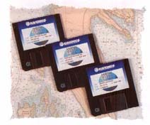 NAVIONICS has unveiled a new series of electronic charts
programmed on standard 3.5" diskettes for use with navigation software programs on a
PC or notebook computer.
NAVIONICS has unveiled a new series of electronic charts
programmed on standard 3.5" diskettes for use with navigation software programs on a
PC or notebook computer.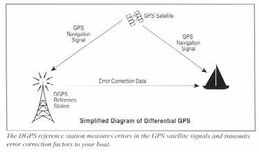
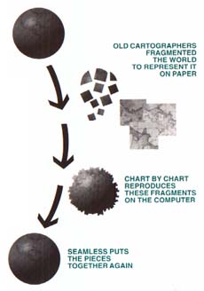 There are two basic ways to manage and display an electronic
chart database.
There are two basic ways to manage and display an electronic
chart database. Raster Charts
 Geographic datum is a
frame of reference used by cartographers to define a chart's grid of coordinates. The
datum can have a significant impact on navigational accuracy.
Geographic datum is a
frame of reference used by cartographers to define a chart's grid of coordinates. The
datum can have a significant impact on navigational accuracy.