|
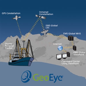
The Osprey personal GPS tracker is an portable terminal for tracking and communicating with your fleet anywhere in the world (Photo: GeoEye )
COMPANY OF THE WEEK: GeoEye Marine Services To Enhance Your Success At Sea
 (UNITED STATES, 4/14/2011)
GeoEye, Inc. (Public, NASDAQ:GEOY) is a premier provider of superior satellite and aerial imagery, location information products and image processing services. Using GeoEye products and services, professionals across the world are able to spend less time searching for information—and more time applying the right insight—no matter what industry they're in.
 |
| GeoEye provides the highest quality and most accurate satellite imagery available |
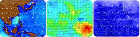
GeoEye Marine Services has specially been tailored to provide fish-finding and oceanic data services and products, tailored to the unique needs of commercial and government maritime organizations. GeoEye’s SeaStar Fisheries Information Service combines ocean plankton data with oceanographic and meteorological data sets from server satellite imaging systems, processed daily by GeoEye’s expert team and delivered directly to the vessel. Specific buoy, vessel tracking, and research products are available. To maximize the usefulness of this information, GeoEye offers OrbMap software, training and technical support to every customer. OrbMap enables captains and fleet managers to manipulate map layers, converting oceanic location intelligence into smart decision-making tools.
The Marine Services include oceanographic maps, asset tracking hardware and information that is required by all maritime agencies to monitor ocean conditions, vessels and fishing gear. GeoEye’s oceanographers produce "fish finding maps" (FFM) by collecting and processing data from several satellite systems to help captains identify the most productive fishing grounds.
 |
| GeoEye Marine Services has provided fish-finding and oceanic data services and products since 1997 |
GeoEye comprehensive line of services and products are designed to save time and fuel, enhancing your success on the sea and offering marine solutions to the Longline, Purse Seine, Pole and Line, Trawl Fishing, Sport Fishing, and Government & Maritime industries. These solutions include:
- SeaStar Fisheries Information Service
- Buoys for Fishing and Tracking
- Vessel Monitoring Service (VMS)
- GeoEye Sport Fishing Services
- OrbView-2 Archive and Oceanographic Data
SeaStar Fisheries Information Service, Oceanographic Intelligence, Delivered Fresh Daily
Commercial fishermen want to get to the catch as quickly and cost-effectively as possible. GeoEye's SeaStar Commercial Fishing Service gives the location information needed to make that happen. Plankton concentration data is collected, combined with oceanographic and meteorological information, and processed daily. From there, it's sent directly to the fishing vessel, where the captain can use it to promptly navigate to the closest and potentially most plentiful fishing areas.
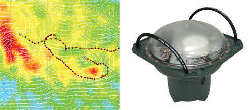 |
| GeoEye OrbBuoys can be tracked and controlled using OrbMap software, allowing fishermen to integrate and display OrbBuoy position information with SeaStar oceanographic maps |
Buoys for Fishing & Tracking
With GeoEye's OrbBuoy™ you will be able to know where your buoy is at any time – anywhere in the world. GeoEye's OrbBuoy™ is easy for an owner to retrieve, yet it's designed to avoid detection and theft. The OrbBuoy is retrieved using high-accuracy GPS, a high-intensity night time recovery beacon and two-way communication via the INMARSAT IsatM2M satellite network.
Vessel Monitoring Service
GeoEye’s SeaStar allows you to track your vessel worldwide with advanced GPS and mapping capabilities. GeoEye’s SeaStar Vessel Monitoring Service (VMS) includes the SAT-202 Vessel Tracking Unit (VTU) and the Osprey Personal Tracker. With GeoEye, the location of your fleet or task force is knowable, manageable, and compatible with other critical location intelligence.
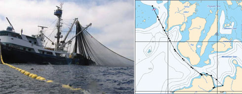 |
| The SAT-202 satellite terminal is the latest in a line of affordable and reliable tracking solutions offered by GeoEye; using the OrbMap software, you can display the tracking information right on your SeaStar oceanographic maps |
Sport Fishing Services
GeoEye’s Sport Fishing Pro Services offer precise oceanographic information, previously available only to commercial fishermen. SeaStar’s OrbMap software offers an organized, scientific record of catch data for all data sets, and an unparalleled ability to learn from oceanic data sets instead of a simple picture.
OrbView-2 Archive and Oceanographic Data
Historical global ocean colour and chlorophyll-a data are available for research and commercial applications from GeoEye's Orbview-2 (OV-2) satellite. The satellite, with its Sea-viewing Wide Field-of-view Sensor (SeaWiFS), operated from August 1997 – February 2011. OrbView-2 made priceless contributions to the study of our oceans, ecosystems, global climate change and other areas of great importance to society.
About GeoEye, Inc.
GeoEye, Inc. is a premier provider of superior satellite and aerial imagery, location information products and image processing services. GeoEye products and services enable timely, accurate and accessible location intelligence that translates into timely and vital insights for its customers, anywhere and at any time. The company owns and operates the world’s highest resolution satellite, GeoEye-1, providing customers with the highest quality and most accurate satellite imagery available. GeoEye anticipates launching its next-generation satellite GeoEye-2 in 2013. Once operational, the satellite will deliver 33-centimeter resolution and provide its customers with ongoing access to industry-leading imagery.
GeoEye has more than 735 employees and is headquartered in Dulles, Virginia, with facilities in Denver (Thornton), Colorado; St. Louis, Missouri; Norman, Oklahoma; and Mission, Kansas.
The Company’s growing global sales network currently comprises 12 strategic business partners (government and commercial) and more than 100 resellers.
GeoEye operates in three areas of the geospatial information services market: imagery collection, geospatial and imagery production and information services. Its capabilities serve market demand worldwide for imagery and information products to map, measure and monitor the Earth for a wide variety of applications.
 |
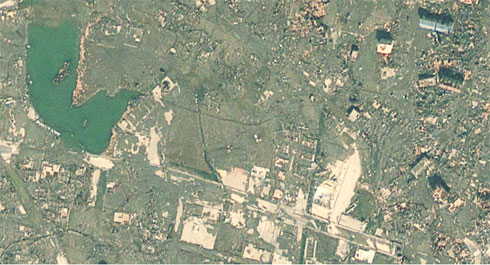
| These half-meter resolution, GeoEye-1 satellite images show Rikuzentakata, Japan before and after a 9.0-magnitude earthquake struck the Oshika Peninsula on March 11, 2011. The before image was taken on July 23, 2010 |
 |
|
The after image was taken at 10:21 a.m. (local time) on March 13, 2011
In the aftermath of Japan's earthquake and tsunami
devastation, GeoEye is providing before-and-after satellite
imagery to assist partners, governments and global media
|
Source: GeoEye, Inc.
Related News
Margaret E.L. Stacey
Editor Companies and Products
[email protected]
www.seafood.media
Information of the company:
|
Address:
|
2325 Dulles Corner Blvd
|
|
City:
|
Herndon
|
|
State/ZIP:
|
Virginia (VA 20171)
|
|
Country:
|
United States
|
|
Phone:
|
+1 703 480 7500
|
|
Fax:
|
+1 703 450 9570
|
|
E-Mail:
|
[email protected]
|
More about: 
|
|
|
|


 Print
Print